Senin, 23 Desember 2013

Hitachi Seaside Park, Japan


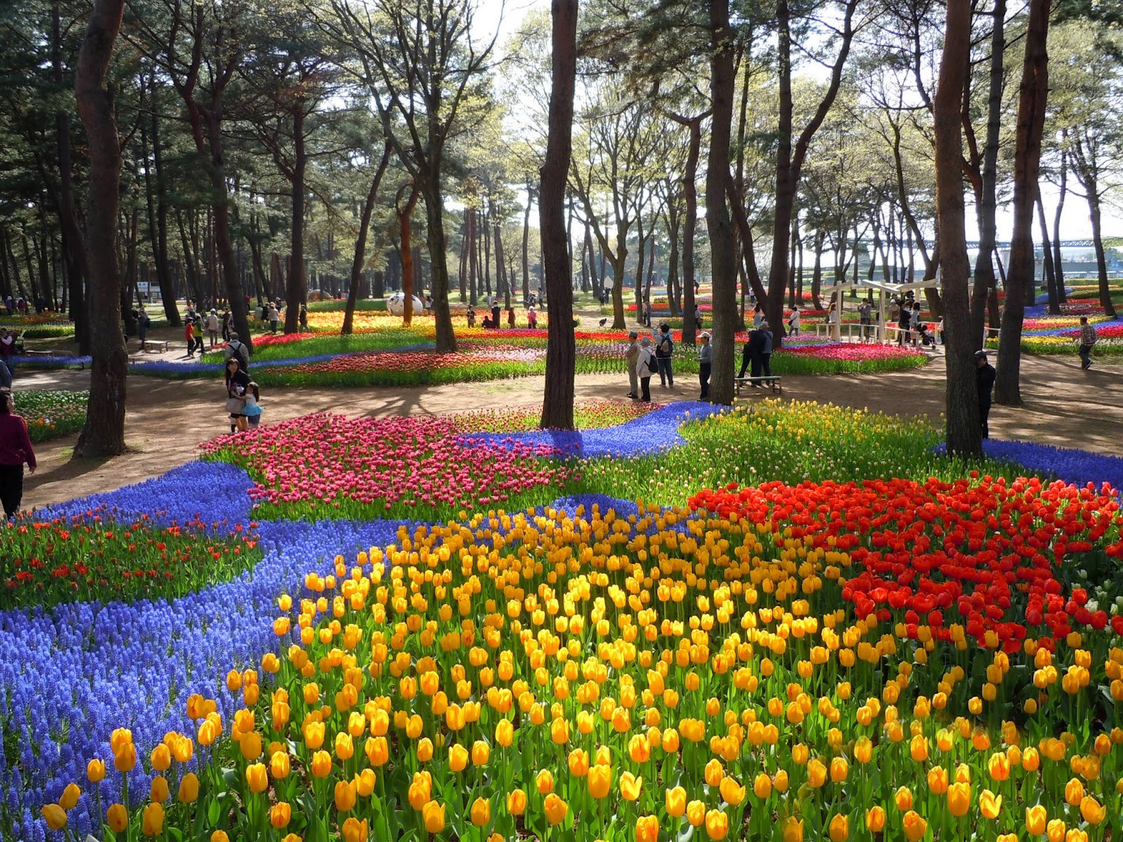
Hitachi Seaside Park (ひたち海浜公園, Hitachi Kaihin Kōen) is a spacious park in ibaraki Prefecture featuring a variety of green spaces and seasonal flowers spread out across 350 hectares, as well as an amusement park and several cycling and walking trails.
The park's iconic flower is the blue nemophila, which covers Miharashi Hill in the spring and mimics the color of the sky. The flowers are usually at their peak from late April to mid May. Paths crisscross the hill providing views over the Pacific Ocean and the rest of the park. In fall, the hill is covered by green kokia bushes which slowly turn red as the weather turns cooler. These autumnal colors are usually best from early to mid October.

Image result for Hitachi Seaside Park, Japan

Although the nemophila are the most well-known of the park's flowers, assorted other flowers bloom throughout most of the year. Near the park's main entrance is a large forested area featuring the Suisen Garden where narcissus usually bloom from mid March, while across the lake tulips bloom usually around late April.

Although flowers are seasonal highlights, the park can be enjoyed year round. There are walking trails through the extensive Hitachinaka Nature Forest, while the Dune Garden showcases plants native to the coastline of Japan. Even when the rest of the park is crowded, this area often remains relatively quiet.

Image result for Hitachi Seaside Park, Japan

Hitachi Seaside Park also features a small amusement park with over 25 rides and attractions, including a 100 meter tall Ferris wheel, putter golf, a BMX course and a roller coaster among others. Most of the rides and activities require extra fees. Restaurants and rest areas are scattered throughout the park, and a BBQ area is available for picnics.

Due to the size of the park, there are two other methods of getting around besides walking. Rental bicycles are available starting from 400 yen for three hours of use, and almost eleven kilometers of cycling paths - separate from pedestrian paths - allow easy access to the different areas of the park. A small train (on tires) also travels the perimeter of the park with stops at numerous locations. The train costs 550 yen for a 1-day pass.

Image result for Hitachi Seaside Park, Japan

Image result for Hitachi Seaside Park, Japan

Selasa, 15 Oktober 2013

Marble Caverns of Carrera Lake – Chile


Image result for Marble Caverns of Carrera Lake – Chile

Dubbed as the most beautiful cave network in the world, Cuevas de Marmol is a 6,000 year-old sculpture hewn by the crashing waves of Lake General Carrera of Patagonia in Southern Chile. Also called the Marble Cathedral, the intricate caverns are part of a peninsula made of solid marble surrounded by the glacial Lake General Carrera that spans the Chile-Argentina border. The swirling pattern on the cave interiors are a reflection of the lake’s azure waters, which change depending on the water levels dictated by weather and season.

Visitors are enamored by the Marble Cave’s unique ability to constantly change its appearance. In early spring, the shallow waters are turquoise and creates a crystalline shimmer against the caves’ swirling walls. Come summer, the water levels increase and create a deep blue hue which gives the cave a unique unearthly shade. The water levels are significantly affected by the freezing and melting of the surrounding glaciers. It’s also from these glaciers where the lake takes the fine silt sediments that rest on the lake bed.

Image result for Marble Caverns of Carrera Lake – Chile

To get to the caves, one must embark on a long and difficult journey starting from a flight to the Chilean capital of Santiago. Visitors must then travel an 800 miles on major highways to the next big city Coyhaique, followed by a 200-mile drive on rough dirt roads towards the lake. Finally, a boat is needed to access the caves. But though the journey is long and challenging, many agree the enchanting beauty of the caves is definitely worth the effort.

Image result for Marble Caverns of Carrera Lake – Chile


Rabu, 11 September 2013

Colosseum, Italy

Image result for Colosseum, Italy

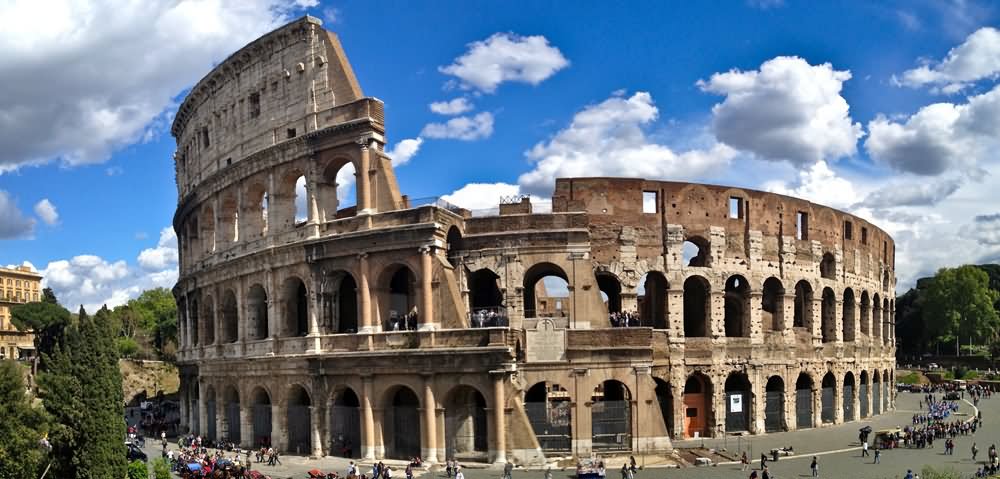
Reconstruction of the Colosseum starting from the orders of King Vespasian in 72 AD and completed by his son Titus in 80 AD Colosseum established close to a magnificent palace formerly built Nero, named Domus Aurea was built after the great fire of Rome in AD 64. Dio Cassius a historian says that there are about 9000 wild animals that have been killed in 100 days as a celebration of the inauguration and opening of the Colosseum. The floor of the Colosseum arena covered with sand to prevent blood-blood does not flow freely in the

Image result for Colosseum, Italia

Image result for Colosseum, Italia

The name of the Coliseum as in the above is taken from the name of a statue as high as 130 feet or 40 m, Colossus. Colossus statue remade as a replacement for Nero as the parable of the sun god Sol, by adding a solar crown. In a mid-year, colossus statue has disappeared. An expert said that since the statue was made of bronze, the sculpture has melted down for reuse.

In addition to a name taken from the Coliseum, the Coliseum also known as the Flavian Amphitheatre is not known who gave the name. In Italy, the Coliseum was named il colosseo but other Roman languages use the name Le Colisee and el coliseo to mention the Colosseum.


Kamis, 25 Juli 2013

Taj Mahal, India

Image result for Taj Mahal, India

The Taj Mahal is located on the right bank of the Yamuna River in a vast Mughal garden that encompasses nearly 17 hectares, in the Agra District in Uttar Pradesh. It was built by Mughal Emperor Shah Jahan in memory of his wife Mumtaz Mahal with construction starting in 1632 AD and completed in 1648 AD, with the mosque, the guest house and the main gateway on the south, the outer courtyard and its cloisters were added subsequently and completed in 1653 AD. The existence of several historical and Quaranic inscriptions in Arabic script have facilitated setting the chronology of Taj Mahal. For its construction, masons, stone-cutters, inlayers, carvers, painters, calligraphers, dome builders and other artisans were requisitioned from the whole of the empire and also from the Central Asia and Iran. Ustad-Ahmad Lahori was the main architect of the Taj Mahal.
The Taj Mahal is considered to be the greatest architectural achievement in the whole range of Indo-Islamic architecture. Its recognised architectonic beauty has a rhythmic combination of solids and voids, concave and convex and light shadow; such as arches and domes further increases the aesthetic aspect. The colour combination of lush green scape reddish pathway and blue sky over it show cases the monument in ever changing tints and moods. The relief work in marble and inlay with precious and semi precious stones make it a monument apart. 
Image result for Taj Mahal, India
The uniqueness of Taj Mahal lies in some truly remarkable innovations carried out by the horticulture planners and architects of Shah Jahan. One such genius planning is the placing of tomb at one end of the quadripartite garden rather than in the exact centre, which added rich depth and perspective to the distant view of the monument. It is also, one of the best examples of raised tomb variety. The tomb is further raised on a square platform with the four sides of the octagonal base of the minarets extended beyond the square at the corners. The top of the platform is reached through a lateral flight of steps provided in the centre of the southern side. The ground plan of the Taj Mahal is in perfect balance of composition, the octagonal tomb chamber in the centre, encompassed by the portal halls and the four corner rooms. The plan is repeated on the upper floor. The exterior of the tomb is square in plan, with chamfered corners. The large double storied domed chamber, which houses the cenotaphs of Mumtaz Mahal and Shah Jahan, is a perfect octagon in plan. The exquisite octagonal marble lattice screen encircling both cenotaphs is a piece of superb workmanship. It is highly polished and richly decorated with inlay work. The borders of the frames are inlaid with precious stones representing flowers executed with wonderful perfection. The hues and the shades of the stones used to make the leaves and the flowers appear almost real. The cenotaph of Mumtaz Mahal is in perfect centre of the tomb chamber, placed on a rectangular platform decorated with inlaid flower plant motifs. The cenotaph of Shah Jahan is greater than Mumtaz Mahal and installed more than thirty years later by the side of the latter on its west. The upper cenotaphs are only illusory and the real graves are in the lower tomb chamber (crypt), a practice adopted in the imperial Mughal tombs.

Image result for Taj Mahal, India

The four free-standing minarets at the corners of the platform added a hitherto unknown dimension to the Mughal architecture. The four minarets provide not only a kind of spatial reference to the monument but also give a three dimensional effect to the edifice.
The most impressive in the Taj Mahal complex next to the tomb, is the main gate which stands majestically in the centre of the southern wall of the forecourt. The gate is flanked on the north front by double arcade galleries. The garden in front of the galleries is subdivided into four quarters by two main walk-ways and each quarters in turn subdivided by the narrower cross-axial walkways, on the Timurid-Persian scheme of the walled in garden. The enclosure walls on the east and west have a pavilion at the centre.
The Taj Mahal is a perfect symmetrical planned building, with an emphasis of bilateral symmetry along a central axis on which the main features are placed. The building material used is brick-in-lime mortar veneered with red sandstone and marble and inlay work of precious/semi precious stones. The mosque and the guest house in the Taj Mahal complex are built of red sandstone in contrast to the marble tomb in the centre. Both the buildings have a large platform over the terrace at their front. Both the mosque and the guest house are the identical structures. They have an oblong massive prayer hall consist of three vaulted bays arranged in a row with central dominant portal. The frame of the portal arches and the spandrels are veneered in white marble. The spandrels are filled with flowery arabesques of stone intarsia and the arches bordered with rope molding.

Selasa, 04 Juni 2013

Great Wall of China

Image result for great wall of china

The Great Wall of China is a barrier fortification in northern China running west-to-east from the Jiayuguan Pass (in the west) to the Hushan Mountains in Liaoning Province in the east, ending at the Bohai Gulf. It crosses eleven provinces/municipalities (or ten, according to some authorities) and two autonomous regions (Inner Mongolia and Ningxia). Construction of the wall began in the Qin Dynasty (221-206 BCE) under the First Emperor Shi Huangti and continued over hundreds of years throughout many different dynasties. The Great Wall in the present day is almost completely the work of the Ming Dynasty (1368-1664 CE) who added the distinctive watchtowers and expanded the length and width of the wall. The now-famous national monument fell into decay following the Ming Dynasty, when the Qing Dynasty (1644-1912 CE) took power and expanded the border of China northwards, making the wall obsolete. Restoration and preservation efforts only seriously began in the 1980's CE, and the wall was declared a UNESCO World Heritage Site in 1987 CE

Image result for great wall of china

In addition to creating the massive wall, the Ming Dynasty also enclosed their most important agricultural center, Liaoning Province, behind a walled fortification known as the Liaoning Wall (also known as the Liaodong Wall). This wall has been a source of controversy between China and North Korea since 2009 CE when the Chinese government claimed they had only recently discovered portions of the Great Wall close to the border with North Korea by the Hushan Mountains. North Korea has asserted that the 'newly discovered Great Wall' actually belongs to them and is not part of China's Great Wall. The section of wall in dispute is no doubt part of the Liaoning Wall. This wall in no way can be compared with the Great Wall and was never built to be. It was a simple defensive barrier constructed to hamper invasions of Liaoning from the north and was constructed of earth, stone, and whatever else was available. Moats were dug on either side of the wall to further impede an invading force.

Image result for great wall of china

here were efforts over the years to maintain the structure, but no concerted effort existed until as recently as 1980 CE when the wall was made a priority of the Chinese government as a tourist attraction and source of revenue. It was not designated a UNESCO World Heritage Site until 1987 CE, but even with that designation the wall is slowly crumbling. Today, according to historians and preservationists who monitor the site, there are only about 600 miles (372 km) of the wall left in stable condition.
There are many modern misconceptions concerning the Great Wall of China. The best known and most often repeated is that it is the only human-made structure on earth that can be seen from space; this is not true. The origin of this claim is the English essayist Sir Henry Norman, who wrote in 1895 that the wall was "the only work of human hands on the globe visible from the moon." His observation was based on the fact that people on earth could see craters and canals on the moon, and so someone on the moon would be able to see something as long and massive as the Great Wall on earth. Many people seem to believe that the claim the wall can be seen from the moon is based on first-hand accounts of astronauts or the work of scientists and astronomers, but it is actually the creation of a man who wrote when space travel was not even possible. Modern day scholars and scientists, as well as those who have traveled to the moon, have debunked this claim repeatedly.


Selasa, 23 April 2013

Great Barrier Reef, Australia

Image result for Great Barrier Reef, Australia

The Great Barrier Reef is blessed with the breathtaking beauty of the world’s largest coral reef. The reef contains an abundance of marine life and comprises of over 3000 individual reef systems and coral cays and literally hundreds of picturesque tropical islands with some of the worlds most beautiful sun-soaked, golden beaches.

Because of its natural beauty, the Great Barrier Reef has become one of the worlds most sought after tourist destinations. A visitor to the Great Barrier Reef can enjoy many experiences including snorkelling, scuba diving, aircraft or helicopter tours, bare boats (self-sail), glass-bottomed boat viewing, semi-submersibles and educational trips, cruise ship tours, whale watching and swimming with dolphins.

Image result for Great Barrier Reef, Australia

Thirty species of whales, dolphins, and porpoises have been recorded in the Great Barrier Reef, including the dwarf minke whaleIndo-Pacific humpback dolphin, and the humpback whale. Large populations of dugongs live there. More than 1,500 fish species live on the reef, including the clownfishred bass, red-throat emperor, and several species of snapper and coral trout.Forty-nine species mass spawn, while eighty-four other species spawn elsewhere in their range.Seventeen species of sea snake live on the Great Barrier Reef in warm waters up to 50 metres (160 ft) deep and are more common in the southern than in the northern section. None found in the Great Barrier Reef World Heritage Area are endemic, nor are any endangered.
Six species of sea turtles come to the reef to breed: the green sea turtleleatherback sea turtlehawksbill turtleloggerhead sea turtleflatback turtle, and the Olive Ridley. The green sea turtles on the Great Barrier Reef have two genetically distinct populations, one in the northern part of the reef and the other in the southern part. Fifteen species of seagrass in beds attract the dugongs and turtles, and provide fish habitat. The most common genera of seagrasses are Halophila and Halodule
Image result for Great Barrier Reef, Australia

Senin, 11 Februari 2013

Angkor Wat, Kamboja

Angkor Wat lies 5.5 kilometres (3.4 mi) north of the modern town of Siem Reap, and a short distance south and slightly east of the previous capital, which was centred at Baphuon. In an area of Cambodia where there is an important group of ancient structures, it is the southernmost of Angkor's main sites.
According to legend, the construction of Angkor Wat was ordered by Indra to act as a palace for his son Precha Ket Mealea.[7]According to the 13th century Chinese traveler Daguan Zhou, it was believed by some that the temple was constructed in a single night by a divine architect.
The initial design and construction of the temple took place in the first half of the 12th century, during the reign of Suryavarman II(ruled 1113 – c. 1150). Dedicated to Vishnu, it was built as the king's state temple and capital city. As neither the foundation stela nor any contemporary inscriptions referring to the temple have been found, its original name is unknown, but it may have been known as "Varah Vishnu-lok" after the presiding deity. Work seems to have ended shortly after the king's death, leaving some of the bas-reliefdecoration unfinished. In 1177, approximately 27 years after the death of Suryavarman II, Angkor was sacked by the Chams, the traditional enemies of the Khmer. Thereafter the empire was restored by a new king, Jayavarman VII, who established a new capital and state temple (Angkor Thom and the Bayon respectively) a few kilometers to the north.
Toward the end of the 12th century, Angkor Wat gradually transformed from a Hindu center of worship to Buddhism, which continues to the present day. Angkor Wat is unusual among the Angkor temples in that although it was somewhat neglected after the 16th century it was never completely abandoned, its preservation being due in part to the fact that its moat also provided some protection from encroachment by the jungle.
Image result for Angkor Wat, Kamboja

Angkor Wat required considerable restoration in the 20th century, mainly the removal of accumulated earth and vegetation.[18] Work was interrupted by the civil war and Khmer Rouge control of the country during the 1970s and 1980s, but relatively little damage was done during this period. Camping Khmer Rouge forces used whatever wood remained in the building structures for firewood, a pavilion was ruined by a stray American shell, and a shoot-out between Khmer Rouge and Vietnamese forces put a few bullet holes in a bas relief. Far more damage was done after the wars, by art thieves working out of Thailand, which, in the late 1980s and early 1990s, claimed almost every head that could be lopped off the structures, including reconstructions.
The temple is a powerful symbol of Cambodia, and is a source of great national pride that has factored into Cambodia's diplomatic relations with France, the United States and its neighbor Thailand. A depiction of Angkor Wat has been a part of Cambodian national flags since the introduction of the first version circa 1863.[20] From a larger historical and even transcultural perspective, however, the temple of Angkor Wat did not become a symbol of national pride sui generis but had been inscribed into a larger politico-cultural process of French-colonial heritage production in which the original temple site was presented in French colonial and universal exhibitions in Paris and Marseille between 1889 and 1937.[21] Angkor Wat's aesthetics were also on display in the plaster cast museum of Louis Delaporte called musée Indo-chinois which existed in the Parisian Trocadero Palace from c.1880 to the mid-1920s.[22]
The splendid artistic legacy of Angkor Wat and other Khmer monuments in the Angkor region led directly to France adopting Cambodia as a protectorate on 11 August 1863 and invading Siam to take control of the ruins. This quickly led to Cambodia reclaiming lands in the northwestern corner of the country that had been under Siamese (Thai) control since AD 1351 (Manich Jumsai 2001), or by some accounts, AD 1431.[23] Cambodia gained independence from France on 9 November 1953 and has controlled Angkor Wat since that time. It is safe to say that from the colonial period onwards until the site's nomination as UNESCO World Heritage in 1992, this specific temple of Angkor Wat was instrumental in the formation of the modern and gradually globalized concept of built cultural heritage

Image result for Angkor Wat, Kamboja

Angkor Wat is the prime example of the classical style of Khmer architecture—the Angkor Wat style—to which it has given its name. By the 12th century Khmer architects had become skilled and confident in the use of sandstone (rather than brick or laterite) as the main building material. Most of the visible areas are of sandstone blocks, while laterite was used for the outer wall and for hidden structural parts. The binding agent used to join the blocks is yet to be identified, although natural resins or slaked lime has been suggested.[35]
The temple has drawn praise above all for the harmony of its design. According to Maurice Glaize, a mid-20th-century conservator of Angkor, the temple "attains a classic perfection by the restrained monumentality of its finely balanced elements and the precise arrangement of its proportions. It is a work of power, unity and style.
Architecturally, the elements characteristic of the style include: the ogival, redented towers shaped like lotus buds; half-galleries to broaden passageways; axial galleries connecting enclosures; and the cruciform terraces which appear along the main axis of the temple. Typical decorative elements are devatas (or apsaras)bas-reliefs, and on pediments extensive garlands and narrative scenes. The statuary of Angkor Wat is considered conservative, being more static and less graceful than earlier work.[37] Other elements of the design have been destroyed by looting and the passage of time, including gilded stucco on the towers, gilding on some figures on the bas-reliefs, and wooden ceiling panels and doors.