Kamis, 11 Desember 2014

Bern, Swiss

Image result for Bern, Swiss 

 The City of Bern is the political centre of Switzerland. It is well-known for its high quality of life, good cultural offering and tourist attracions. Bern is also home to international organisations and enterprises. It has gained itself a reputation as a place of research and science

Image result for Bern, Swiss 

Bern was occupied by French troops in 1798 during the French Revolutionary Wars, when it was stripped of parts of its territories. It regained control of the Bernese Oberland in 1802, and following the Congress of Vienna of 1814, it newly acquired the Bernese Jura. At this time, it once again became the largest canton of the confederacy as it stood during the Restoration and until the secession of the canton of Jura in 1979. Bern was made the Federal City (seat of the Federal Assembly) within the new Swiss federal state in 1848.
A number of congresses of the socialist First and Second Internationals were held in Bern, particularly during World War I when Switzerland was neutral; see Bern International.
The city's population rose from about 5,000 in the 15th century to about 12,000 by 1800 and to above 60,000 by 1900, passing the 100,000 mark during the 1920s. Population peaked during the 1960s at 165,000, and has since decreased slightly, to below 130,000 by 2000. As of October 2015, the resident population stood at 140,634, of which 100,634 were Swiss citizens and 40,000 (30%) resident foreigners. A further estimated 350,000 people live in the immediate urban agglomeration.

Image result for Bern, Swiss 


The city was originally built on a hilly peninsula surrounded by the river Aare, but outgrew natural boundaries by the 19th century. A number of bridges have been built to allow the city to expand beyond the Aare.

Bern is built on very uneven ground. There is an elevation difference of several metres between the inner city districts on the Aare (Matte, Marzili) and the higher ones (Kirchenfeld, Länggasse).

Bern has an area, as of 2009, of 51.62 square kilometers (19.93 sq mi). Of this area, 9.79 square kilometers (3.78 sq mi) or 19.0% is used for agricultural purposes, while 17.33 square kilometers (6.69 sq mi) or 33.6% is forested. Of the rest of the land, 23.25 square kilometers (8.98 sq mi) or 45.0% is settled (buildings or roads), 1.06 square kilometers (0.41 sq mi) or 2.1% is either rivers or lakes and 0.16 square kilometers (0.062 sq mi) or 0.3% is unproductive land.[11]

Of the developed, 3.6% consists of industrial buildings, 21.7% housing and other buildings, and 12.6% is devoted to transport infrastructure. Power and water infrastructure as well as other special developed areas made up 1.1% of the city, while another 6.0% consists of parks, green belts and sports fields. 32.8% of the total land area is heavily forested. Of the agricultural land, 14.3% is used for growing crops and 4.0% is designated to be used as pastures. The rivers and streams provide all the water in the municipality

Image result for Bern, Swiss 

Image result for Bern, Swiss 


Selasa, 04 November 2014

The Pearl Waterfall, Jiuzhaigou Valley, China

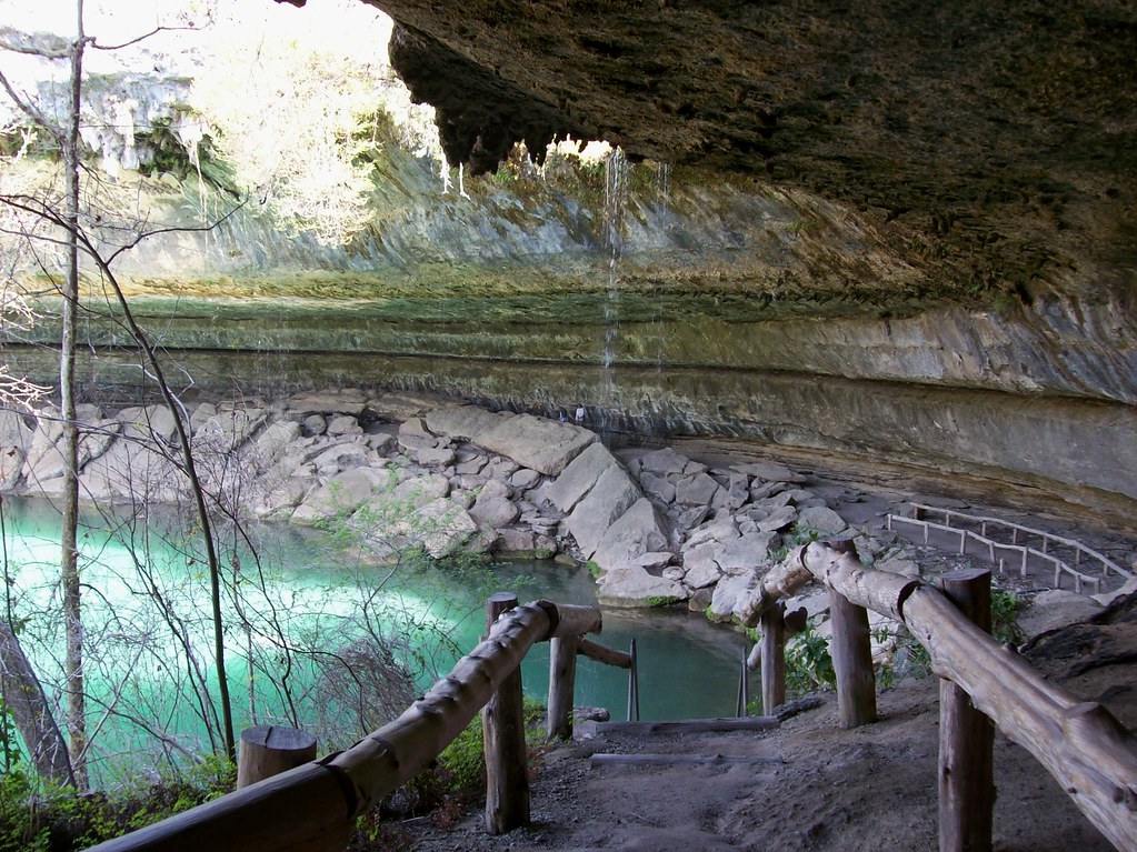
Jiuzhaigou literally means nine-village-valley. It's a valley with nine villages. It's also a popular tourist destination, on UNESCO's World Heritage List. Jiuzhai Valley is most renowned for its stunning natural scenery of colorful lakes, mature forests, and spectacular waterfalls. The beautiful scenery attracts many photographers.
  • Chinese: 九寨沟 (jiǔ zhài gōu, 'nine villages valley')
  • Location: Aba Tibetan and Qiang Autonomous Prefecture, about 490 km north of Chengdu city
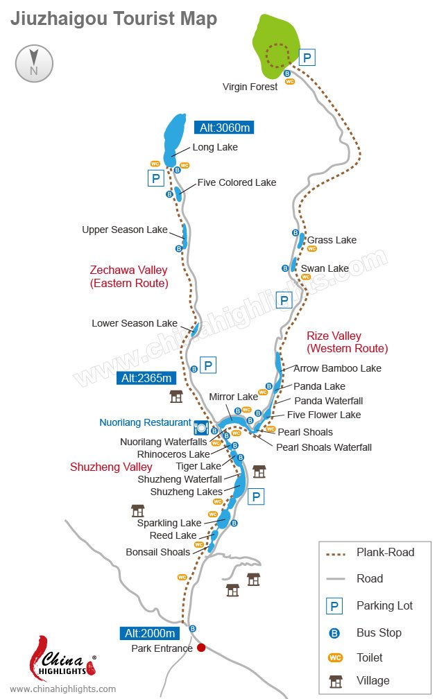
  • Must-see areas: Shuzheng Valley, Rize Valley, Zechawa Valley
  • Time needed: 2-3 days

Best Time to Visit — Fall

jiuzhai valley
Jiuzhai Valley's scenery in fall
Fall has the best scenery in Jiuzhai Valley, with golden foliage. The fall is from September to October. "Golden" can best describe the autumnal park, when fallen leaves render the world completely golden-yellow.
The fall is a peak season for tourism, so hotels, flights, and English-speaking guides may be difficult to arrange. If you are interested in travelling to Jiuzhai Valley during September or October, we recommend you book one or two months in advance.
The park's scenery is stunning and breath-taking all year round, worth appreciating in other seasons as well.
  • Green in spring: when mountains are capped with verdant trees and lakes are peaceful and quiet.
  • Fantastic in summer: to stroll under the pure blue sky, passing colorful oceans of flowers.
  • Snow-capped in winter: a fairy-tale heaven, with beauty that can hardly be described in words.

Park Highlights

The park has 114 lakes or pools and 5 major waterfalls. It may take you more than 3 days to explore everything. We summarize here the main highlights for you.
Shuzheng Valley is a key part of Jiuzhai which you shouldn't miss. Nearly half of the park's lakes and waterfalls are in Shuzheng, including Double-Dragon Lake, Bonsai Beach, Reed Lake, Sparkling Lake, Shuzheng Lakes, Shuzheng Waterfall, Tiger Lake, Rhinoceros Lake, and Nuorilang Waterfall.
Shuzheng Waterfall

Shuzheng Valley — See Most of the Lakes and Waterfalls

Shuzheng Waterfall is the most representative and important attraction in Shuzheng Valley. It's 62 meters wide and 15 meters high, and is the first waterfall after the river enters the valley. The lakes upstream among the shoals and stepping stones make the waterfall more magnificent.
Shuzheng Lakes
Shuzheng Lakes includes 19 lakes of different sizes, featuring different colors, and looking like terraced fields.
Nuorilang Waterfall
Praised as the most beautiful waterfall in Jiuzhai Valley, Nuorilang is also the widest (300 meters). It is at the center of Shuzheng Valley, and regarded as symbolic of Jiuzhai. It is more fabulous in the morning sunshine, especially if attended by a rainbow in the sky. In winter it's a frozen feast for the eyes, appearing as if it's hanging on the rocks.

Rize Valley — Explore the Habitat of the Giant Panda

Image result for image The Pearl Waterfall, Jiuzhaigou Valley, China
Rize Valley is the elite part of the park. It offers an astonishing diversity of spectacular landscapes. Its main attractions include virgin forest, Strawberry Lake, Swan Lake, Panda Lake, Five Flowers Lake, Arrow Bamboo Lake, Pearl Beach Waterfall, and Mirror Lake.
Panda Lake
Giant pandas in Jiuzhai Valley used to love living near Panda Lake. They came here to drink, have fun, and look for food. Fish can be seen in this clear lake, even some rare species.
Five Flowers Lake
Multicolored and famous Five Flowers Lake is named after the flamboyant algae in the water. It looks magical and marvelous. It's actually said to have magical powers, so that the plants watered by the lake grow with particular vigor. And they do!
Arrow Bamboo Lake
Image result for image The Pearl Waterfall, Jiuzhaigou Valley, China
Scores of tall bamboo canes, the favorite food of the giant pandas that used to stroll around Panda Lake, grow around Arrow Bamboo Lake. Reflections of bamboo and the surrounding mountains in the water create a wonderful sight!
The lake flows through the forest, and divides into many small branches, finally ending at Arrow Bamboo Waterfall. In 2001, the famous movie Hero, directed by Zhang Yimou, was shot amongst the charming scenery here.
Pearl Beach Waterfall
Pearl Beach is different from the other lakes in Jiuzhai Valley. It's a wide sandy beach with a bridge over it. Torrential waters from the lakes run under the bridge and crash into some rocks, causing waves to break on the beach. After another 200 meters rapids rush down over a steep cliff. Pearl Waterfall is massive and stirring, well worth photographing.
Image result for image The Pearl Waterfall, Jiuzhaigou Valley, China

Zechawa Valley — See the Largest Lake

Zechawa Valley is about 18 km long, at the highest altitude in the park. The scenery here is just as attractive as elsewhere in Jiuzhai.
Long Lake
Long Lake is the largest lake in the park. It is dark blue, at the end of Zechawa Valley, facing a giant snow mountain and circled by cedars. The surrounding mountains are snow-capped for much of the year. Surveyed from afar, Long Lake looks like a large piece of extraordinary jade nestled among the mountains.
Seasonal Lakes
Image result for image The Pearl Waterfall, Jiuzhaigou Valley, China
Upper Seasonal Lake, Middle Seasonal Lake, and Lower Seasonal Lake are closely connected. Upper Seasonal Lake is surrounded by cliffs. In fall, the waters in the lakes are blue, due to the ample leaves; in spring and winter they are green. In summer, the lakes dry up, and you can see some grass growing on the lake beds among lots of small rocks.
Five-Colored Lake
Five-Colored Lake may be the smallest lake in Jiuzhaigou, but it can still amaze you with its spectacular and fancy colors. When the sun comes out, the lake is even more fabulous and bright, rippling and shining.

See the Best of Jiuzhai Valley with China Highlights

jiuzhai valley
Jiuzhai Valley is a fairyland on earth. But transportation difficulties and exorbitant prices may pose problems when you are planning a Jiuzhai Valley tour. We at China Highlights respectfully recommend the following popular tours for your consideration.
If you have any special things you'd like to do while at Jiuzhai Valley, please just let us know and we'll tailor-make your Jiuzhai Valley tour.

Kamis, 25 September 2014

The Hamilton Pool Nature Preserve in Texas, USA

Image result for The Hamilton Pool Nature Preserve in Texas, USA

Spring is the perfect time of year to explore nature in and around Austin, when it’s warm enough to go for a swim but not so hot that you can’t enjoy an afternoon hike.  It’s also a great time to beat the crowds at some very popular tourist destinations.  On Monday, we took advantage of the school holiday and spent the day at Hamilton Pool Preserve in Dripping Springs, a local hotspot that quickly gets crowded in warmer months.  Featuring a gorgeous grotto and natural swimming area, Hamilton Pool Preserve is a glorious place to swim in cool, clear waters (so clear that you can see the fish as they brush past your legs).

Image result for The Hamilton Pool Nature Preserve in Texas, USA

Hamilton Pool is a natural area that is part of the 30,428-acre Balcones Canyonlands Preserve. Walk inside the walls of the collapsed grotto, step under a waterfall, have a picnic on the (very small) beach area, or go for a hike to the Pedernales River.  There is no better way to spend a few hours in the sun.

Image result for The Hamilton Pool Nature Preserve in Texas, USA

Image result for The Hamilton Pool Nature Preserve in Texas, USA

Image result for The Hamilton Pool Nature Preserve in Texas, USA

Selasa, 05 Agustus 2014

Madeira, Portugal

Image result for Madeira, Portugal

Madeira is not Ibiza. It attracts a more mature clientele, and raving is limited to enthusing about the island’s dramatic scenery and botanical wonders.
One of the earliest ravers was H N Coleridge, nephew of the poet, who waxed lyrical after a visit in 1825: “I should think the situation of Madeira the most enviable on the whole earth. It ensures every European comfort with almost every tropical luxury.” Madeirans know this of course, and over the years have enhanced their quality of life by producing a cornucopia of fine food and wine. They have also helpfully provided access to their tumultuous countryside by building more than 1,000 miles of irrigation channels, accompanied by footpaths that snake through the kind of striking landscapes dreamt up by J R R Tolkien.
Which is how my wife and I find ourselves strolling through a sun-dappled mimosa forest between two renowned botanical gardens, and looking forward to an al fresco lunch on the terrace of a hillside tea room en route. It is midwinter, and there are reports of blizzards sweeping Britain. We try not to feel smug, and fail.
There was a time when I’d trek a strenuous trail over Madeira’s highest mountains, unfazed by sheer cliffs that would appeal to base jumpers. Since then age and a scary incident with a parachute have imbued me with vertigo, and when it comes to narrow paths and exposed edges this Braveheart is more of a Faintheart.
Luckily, our guidebook lists a variety of walks with no such perils, and the Levada dos Tornos between the Palheiro and Funchal municipal botanical gardens is a gentle introduction to them.
Most of the island is an exuberant botanical garden of volcanic soil where just about anything grows, the difference being that the formal gardens have created a semblance of order in the horticultural chaos. Palheiro, in the hills above Funchal, has an outstanding collection of camellias, but the most impressive specimen is a towering Norfolk Island pine from New Zealand, a veritable Lord of the Forest that looks ready to join Frodo Baggins in battle against the evil Sauron. My wife instinctively hugs its massive trunk, and feels better for it. Then I do too.
The beauty of the levadas is that they are fairly level, quiet water channels in rural areas where noise is limited to birdsong, an occasional barking dog and tolling of distant church bells. All of which we hear on a wander along the Levada do Norte between the hill villages of Estreito de Câmara de Lobos and Nogueira. This is the island’s main wine-producing area, a patchwork of precipitous terraced vineyards that appear to defy logic and gravity. Aficionados of Madeira’s fortified wines should know they are produced by back-breaking toil in vineyards not much bigger than back gardens. There is not enough level land here to park a harvesting machine, much less use one.
In a deep, green valley we pass a farmer with two happy dogs tilling his soil, and another bent under the weight of a load of vine branches, and walk over an old stone bridge that looks as if it was built by the Romans.
It is as if we have slipped back in time, and might meet Coleridge around the next corner. Instead we catch a bus back to Estreito, thanks to a villager in Nagueira who helps us to find an unmarked bus stop outside the Café Nicola.
After all this exertion, it is important to have a tranquil refuge to retire to. The former residence of General William Beresford, British military governor of the island in 1808, fits the bill perfectly. The Quinta Jardins do Lago is an elegant country mansion set in formal gardens above the hustle and bustle of Funchal, offering good food and croquet on the lawn. Just the place in which to unwind after an arduous campaign in the Napoleonic Wars, or a brisk stroll along a levada.
It seems most visitors are content to wander around the capital and nearby villages, which is fine with us. This leaves much of the island largely untouched by mass tourism, preserving its rural charm.
And its wildness. The volcanic heart of Madeira, reached on a helter-skelter road winding up above the clouds, is a geological nightmare of splintered rock-like monstrous broken teeth. The road ends at the summit of Pico do Arieiro, the third-highest peak, where a snack bar offers panoramic views of solidified lava and ash that are a vision of the dawn of time. The effect is of a silent, primal scream. There should be signs saying beware of low-flying pterodactyls. Instead, oddly, there is a visitor centre devoted to the endangered Madeiran petrel.
The road north winds down through a gentler landscape of forests and lush valleys reminiscent of Indian hill stations and tea plantations. The locals don’t grow tea, but they cultivate just about everything else on terraces clinging to vertiginous slopes.
The place to head for here is the Quinta do Furão, a country house hotel below Santana with a restaurant terrace perched above a succession of rocky headlands, where the island plunges into the Atlantic with a dramatic flourish. The hotel also has a chef who performs wonders with fresh trout and sea bass, served variously with lemon grass and champagne sauces.
Before leaving, our waiter offers us a glimpse of old Madeira in a dried goatskin. Not so long ago, before the islanders got around to building roads, this was a way of transporting wine from the north to Funchal. Strong men would take two days to traverse the mountainous interior carrying goatskins of wine weighing up to 70kg. At least it was accepted they could lighten their load along the way, and by the time they arrived they were less burdened and less sober.
A more refined approach to wine is taken in the head office and tasting room of Pereira D’Oliveira, purveyor of the island’s finest vintages for more than a century. An air of antiquity mingled with the semi-sweet aromas of wine pervades its 17th-century warehouse in Funchal, where astonishingly venerable wines can be sampled around oak barrel tables.
Looking for a wine to commemorate the building of the Eiffel Tower in 1890, or perhaps to commiserate with the sinking of the Titanic in 1912? Or how about a prized wine from 1850, the year D’Oliveira was founded? All are available, at prices deemed reasonable by connoisseurs.
“They are never easy wines, or ones that immediately win the empathy of the taster,” says Rui Falcão, a respected Portuguese wine writer, “but they are genuine and grandiose, capable of lifting us up and taking our breath away.” A bit like the land they come from. Our final excursion is a walk through sheep farming country that begins and ends at a rustic mountain inn. Inevitably there are no gentle meadows, but instead rumpled green hills and deep valleys with views to the sea that are little short of magical.
It is the weekend, and when we return to the Abrigo do Pastor (Shepherd’s Rest) it is busy with locals tucking in to traditional fare of wild boar steaks with fruit, and various stews featuring goats and rabbits.
I opt for Açorda Madeirense, a spicy soup of bread, olive oil and garlic with poached egg, and listen to our waiter speaking of his homeland. “This is a small island, but visitors often get lost, and even I don’t know all of it. There is much to discover.” As Mr Coleridge rightly observed.

Kamis, 26 Juni 2014

Giza Pyramids, Egypt

pyramids of Giza, Arabic Ahrāmāt Al-Jīzah, Giza also spelled Gizeh, three 4th-dynasty (c. 2575–c. 2465 bce) pyramids erected on a rocky plateau on the west bank of the Nile River near Al-Jīzah (Giza) in northern Egypt. In ancient times they were included among the Seven Wonders of the World. The ancient ruins of the Memphis area, including the Pyramids of Giza, Ṣaqqārah, Dahshūr, Abū Ruwaysh, and Abū Ṣīr, were collectively designated a UNESCO World Heritage site in 1979.

Image result for Giza Pyramids, Egypt

Image result for Giza Pyramids, Egypt

The designations of the pyramids—Khufu, Khafre, and Menkaure—correspond to the kings for whom they were built. The northernmost and oldest pyramid of the group was built for Khufu (Greek: Cheops), the second king of the 4th dynasty. Called the Great Pyramid, it is the largest of the three, the length of each side at the base averaging 755.75 feet (230 metres) and its original height being 481.4 feet (147 metres). The middle pyramid was built for Khafre (Greek: Chephren), the fourth of the eight kings of the 4th dynasty; the structure measures 707.75 feet (216 metres) on each side and was originally 471 feet (143 metres) high. The southernmost and last pyramid to be built was that of Menkaure (Greek: Mykerinus), the fifth king of the 4th dynasty; each side measures 356.5 feet (109 metres), and the structure’s completed height was 218 feet (66 metres). All three pyramids were plundered both internally and externally in ancient and medieval times. Thus, the grave goods originally deposited in the burial chambers are missing, and the pyramids no longer reach their original heights because they have been almost entirely stripped of their outer casings of smooth white limestone; the Great Pyramid, for example, is now only 451.4 feet (138 metres) high. That of Khafre retains the outer limestone casing only at its topmost portion. Constructed near each pyramid was a mortuary temple, which was linked via a sloping causeway to a valley temple on the edge of the Nile floodplain. Also nearby were subsidiary pyramids used for the burials of other members of the royal family.

Image result for Giza Pyramids, Egypt

Khufu’s pyramid is perhaps the most colossal single building ever erected on the planet. Its sides rise at an angle of 51°52′ and are accurately oriented to the four cardinal points of the compass. The Great Pyramid’s core is made of yellowish limestone blocks, the outer casing (now almost completely gone) and the inner passages are of finer light-coloured limestone, and the interior burial chamber is built of huge blocks of granite. Approximately 2.3 million blocks of stone were cut, transported, and assembled to create the 5.75-million-ton structure, which is a masterpiece of technical skill and engineering ability. The internal walls as well as those few outer-casing stones that still remain in place show finer joints than any other masonry constructed in ancient Egypt.

Image result for Giza Pyramids, Egypt

The entrance to the Great Pyramid is on the north side, about 59 feet (18 metres) above ground level. A sloping corridor descends from it through the pyramid’s interior masonry, penetrates the rocky soil on which the structure rests, and ends in an unfinished underground chamber. From the descending corridor branches an ascending passageway that leads to a room known as the Queen’s Chamber and to a great slanting gallery that is 151 feet (46 metres) long. At the upper end of this gallery, a long and narrow passage gives access to the burial room proper, usually termed the King’s Chamber. This room is entirely lined and roofed with granite. From the chamber two narrow shafts run obliquely through the masonry to the exterior of the pyramid; it is not known whether they were designed for a religious purpose or were meant for ventilation. Above the King’s Chamber are five compartments separated by massive horizontal granite slabs; the likely purpose of these slabs was to shield the ceiling of the burial chamber by diverting the immense thrust exerted by the overlying masses of masonry.


Kamis, 01 Mei 2014

Cappadocia, Turkey

Image result for Cappadocia, Turkey

Cappadocia is a geological oddity of honeycombed hills and towering boulders of otherworldly beauty. The fantastical topography is matched by the human history here. People have long utilised the region's soft stone, seeking shelter underground and leaving the countryside scattered with fascinating cavern architecture. The fresco-adorned rock-cut churches of Göreme Open-Air Museum and the subterranean refuges of Derinkuyu and Kaymaklı are the most famous sights, while simply bedding down in one of Cappadocia's cave hotels is an experience in 21st-century cave living.
Whether you're wooed here by the hiking potential, the history or the bragging rights of becoming a modern troglodyte for a night, it's the lunarscape panoramas that you'll remember. This region's accordion-ridged valleys, shaded in a palette of dusky orange and cream, are an epiphany of a landscape – the stuff of psychedelic daydreams.

Image result for Cappadocia, Turkey

This tour can be designed on private basis for your own choice of pace and interest.
Flying in a Cappadocia hot air balloon tour is an amazing and unforgettable experience which you will never forget.  Very early in the morning you will be picked up from your hotel and transferred to our balloon site. You will be welcomed with a light breakfast while you are registering for your flight. After meeting at the balloon site you will be watching how we prepare our balloons for your adventure. After getting on the air you will be seeing beautiful sunrise upon Cappadocia. You will be thrilled with the scale of colors and shapes. We will be ascending up to 3000 feet and then almost you will be able touch fairy chimneys. After landing we will celebrate our flight with champagne toast (or soft drink) and your pilot will be presenting your flight certificates. After deflation balloons you will be transported to your launch site and continue to your day.

Image result for Cappadocia, Turkey

Image result for Cappadocia, Turkey